Upper Neuse Clean Water Initiative Recognized for Land Protection

The Upper Neuse Clean Water Initiative (Initiative) was recently recognized for its expansive efforts to protect drinking water and the watersheds that support citizens in central North Carolina. The North Carolina Source Water Collaborative awarded the Initiative its 2017 Award of Excellence for Surface Water Planning and Surface Water Implementation. The award was presented at the Water Resources Research Institute conference in Raleigh.

“It is an incredible honor to be recognized by the North Carolina Source Water Collaborative for the critical work of conservation partners and local governments across the region,” said Caitlin Burke, CTNC Associate Director. “Land protection is one of the most effective ways to protect drinking water sources and limit runoff pollution while maintaining wildlife habitat, preserving open space, and providing recreational opportunities for local communities.”

As of December 2016, partners had completed 98 projects protecting 8,048 acres and land along 89 miles of streams in North Carolina’s Upper Neuse River Basin. In fall 2016 alone, partners protected 40 acres in Wake County, 33 acres in Durham County, and 114 acres in Orange County, and ensuring protective buffers along 6,851 feet of streams.

Additionally, 10 projects currently are in process. One those are completed, the Upper Neuse Clean Water Initiative will celebrate another milestone – conserving 10,000 acres and more than 100 miles of streams so local residents have access to safe, clean drinking water.

The Initiative is made up of nonprofit organizations and local governments that protect the lands most critical for ensuring the long-term health of drinking water supplies in the Upper Neuse Basin, which serve more than 600,000 people in Wake, Durham, Orange, Granville, Franklin, and Person counties.

NC land trusts involved in the Upper Neuse Clean Water Initiative include the Conservation Trust for North Carolina (coordinator), Ellerbe Creek Watershed Association, Eno River Association, Tar River Land Conservancy, Triangle Greenways Council, Triangle Land Conservancy, and The Conservation Fund.
Triangle Farms for Food: Strategy + Action Plan

The Conservation Trust for North Carolina, with grant support from the Triangle Community Foundation, developed a regional farmland preservation and agricultural development strategy for the Triangle. The project area includes Chatham, Durham, Johnston, Orange, and Wake counties.

The project:

  • Prioritizes farmland protection areas in the Triangle.
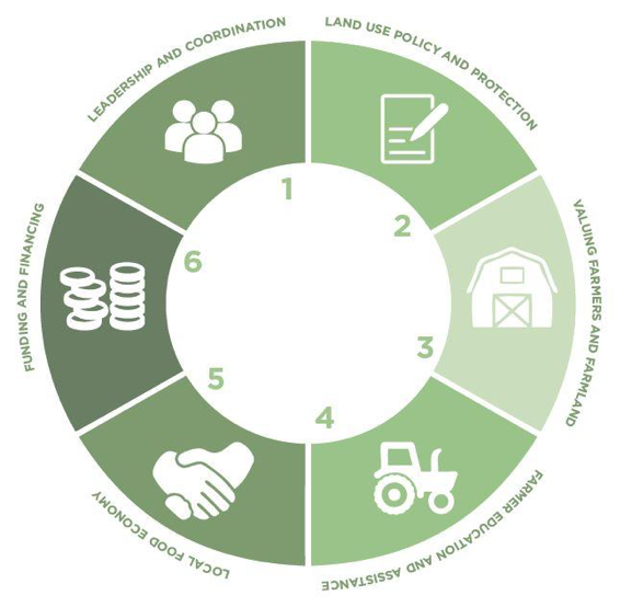
  • Identifies six strategies to conserve farmland, assist farmers, and support local food production.
  • Proposes six place-based approaches to address local opportunities for farmland preservation and community economic development.
  • Lays out a three-year action plan to guide initial efforts.

Download a copy of the full report designed by Community Food Lab.

Appendices Links

  1. GIS Farmland Prioritization Methods
  2. GIS Mapping Results
  3. List of Contributing Resource Professionals
  4. List of Contributing Stakeholders
  5. Stakeholders Ideas and Input
    1. Values
    2. Strategies
    3. Place-based Activities

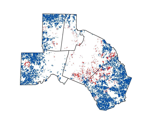
Farmland Protection Priority Areas

Blue – Top scoring rural farm parcels.
Red – Top scoring urban farm parcels.

Project Partners

  • Conservation Trust for North Carolina
  • Community Food Lab
  • Center for Environmental Farming Systems
  • Carolina Farm Stewardship Association
  • Triangle Land Conservancy
  • Eno River Association
  • Sustainable Foods North Carolina

Our Collective Vision

Active, productive, and economically viable farms are common sights throughout the Triangle’s rural and urban landscapes, contributing to sustainable communities and a resilient regional food system.

Six Regional Strategies to Protect Farmland and Grow the Local Food Economy

Six Place-Based Strategies

  • Southeastern Johnston County Large Farms
  • Western Chatham County Large Farms and Livestock
  • Northern Orange and Durham Counties: Transition and New Markets
  • Urban Agriculture Focus in Durham and Wake Counties
  • County Line: Wake and Johnston County Small Farm Networks
  • Siler City Farm Ring

Triangle Farms for Food Strategy + Action Plan Provides Road Map for Farmland Preservation and Local Food Economy

Click Here to Download the Triangle Farms For Food: Strategy + Action Plan.

The market for fresh local food continues to grow in the Triangle region, but development pressures on existing farms and the lack of access to farmland for new farmers are major barriers to increasing local food production. There is a critical need to protect farmland to provide long-term food security for all Triangle residents.

The Conservation Trust and its partners have completed a regional farmland preservation and agricultural economic development strategy for the Triangle. With grant support from the Triangle Community Foundation and Sustainable Foods NC, CTNC has published, “Triangle Farms for Food: Strategy + Action Plan.”

Click here to download the full report and additional supporting materials.

Partners

In addition to the Triangle Community Foundation and Sustainable Foods NC, partners included Community Food Lab, Triangle Land Conservancy, Eno River Association, Center for Environmental Farming Systems and Carolina Farm Stewardship Association. The overall goals of the partners are to protect existing farmland and keep it in production, support existing and beginning farmers, advance agricultural awareness and build a strong local food economy in the region.

Strategy

The strategy covers Chatham, Durham, Johnston, Orange and Wake Counties. These five counties combined have lost more than 63,500 acres of farmland since 1997. The strategy uses Geographic Information System (GIS) analysis to prioritize farmland for protection in the five-county region. The criteria for prioritizing rural farmland included prime soils, agricultural land cover, farm size, proximity to protected farmland, development pressure and distance to markets.  The strategy also prioritizes smaller farms in proximity to urban areas and food deserts that can serve as the focal point for farmland preservation and urban agricultural development.

Impact

The report identifies 788 parcels consisting of more than 50,000 acres of farmland in rural areas and 65 parcels consisting of more than 850 acres in urban areas as high priority farmland. Based on the GIS data and feedback from stakeholders throughout the region, the project partners developed six place-based strategies and six regional strategies to promote farmland preservation and agricultural economic development across the Triangle.

The Conservation Trust will continue working with partners in the region to implement the strategy and three-year action plan to achieve our collective vision: active, productive, and economically-viable farms are common sights throughout the Triangle’s rural and urban landscapes, contributing to sustainable communities and a resilient regional food system.

This post was co-authored by Edgar Miller, Government Relations Director and Caitlin Burke, Special Projects and Grants Coordinator. To learn more about Triangle Farms for Food click here. 

Website, Booklet Promote Blue Ridge Parkway Successes

Use ProtectTheBlueRidgeParkway.org to plan your next Parkway trip and enjoy vibrant colors from a land trust-protected property!

Nonprofit land trusts launch interactive website highlighting protected lands along the Parkway in North Carolina

Eight partner land conservation organizations recently launched an interactive website highlighting every land protection project they’ve completed along the North Carolina section of the Blue Ridge Parkway. The website touts 76 properties totaling 63,948 acres protected as of December 31, 2015 by local, statewide and national nonprofit land conservation organizations.  The web link is protecttheblueridgeparkway.org.

The website includes photos and property descriptions, including availability for hiking, an interactive map, and information about each partner land trust and the Blue Ridge Parkway. “We hope this site will raise awareness about the great work being done by land trusts to protect the integrity of the Blue Ridge Parkway,” said CTNC Executive Director Reid Wilson. “We also hope it will serve as an interactive guide for visitors seeking hiking opportunities and more information about scenic views along the Parkway.”

“Working in partnership with conservation organizations to protect lands and ensure these views are available for generations to come is a gift,” said Mark Woods, Superintendent of the Blue Ridge Parkway.

The website complements a booklet recently published that contains the same content. The website will be updated to reflect future completed conservation projects. For a paper copy of the booklet, contact CTNC at 919-828-4199 ext. 17 or info@ctnc.org.

The land trusts protecting the natural, cultural and economic value of the Blue Ridge Parkway in North Carolina include: Blue Ridge Conservancy, The Conservation Fund, Conservation Trust for North Carolina, Foothills Conservancy of North Carolina, Mainspring Conservation Trust, The Nature Conservancy, Piedmont Land Conservancy, and Southern Appalachian Highlands Conservancy.

Our Blue Ridge Parkway booklet and website was featured by the Asheville Citizen-Times! Read the full story here!

Doughton Park Expanded, Blue Ridge Parkway Vistas Protected

Blue Ridge Conservancy and CTNC Team Up to Conserve 103 Acres in Alleghany County

Blue Ridge Conservancy (BRC) and the Conservation Trust for North Carolina (CTNC) jointly purchased a 103-acre property along the Blue Ridge Parkway in Alleghany County.  The land borders the Parkway and Doughton Park for approximately 4,000 feet and features both scenic vistas and important wildlife habitat.

This section of the Parkway was cut into the north side of Bluff Mountain where ice coats the rocks above the road, thus giving this area the name “Ice Rock.” The Ice Rock is a popular destination for ice climbing in the winter when the Parkway is closed.

BRC and CTNC plan to donate this land to the National Park Service to be managed as part of Doughton Park and the Blue Ridge Parkway.  The addition of this property to the Parkway will preserve the scenic vistas along the Parkway and increase the connectivity of protected lands in the area.

“Protecting the High Country’s scenic vistas and mountain landscapes is part of Blue Ridge Conservancy’s mission,” said Walter Clark, BRC Executive Director. “With the National Park Service’s Centennial this year, we celebrate the Parkway as the most frequently visited national park unit in the country.  BRC is proud to partner with CTNC to conserve these iconic views along this one-of-a-kind scenic byway.”

Doughton Park hosts 30 miles of hiking trails with open meadows, campgrounds, healthy forests and abundant wildlife viewing.  The park offers a variety of cultural and historical demonstrations by NPS staff.  “The Doughton Park section of the Blue Ridge Parkway has a special place in the Parkway’s history,” said Parkway Superintendent Mark Woods.  “It is among the oldest sections of the Parkway, yet with this newly protected tract and renewed interest in other attractions in this area, the future is very bright.”

“We are thrilled to have a small part in protecting this incredible view for all Parkway visitors to enjoy and encourage everyone to get out and explore Doughton Park,” said Margaret Newbold, CTNC Associate Director.

Funding for the Ice Rock project was made possible by a generous donation from Fred and Alice Stanback.

Blue Ridge Conservancy, the Conservation Trust for North Carolina and several other partners recently launched a website highlighting land trust protected properties along the NC section of the Blue Ridge Parkway.  The web link is:  http://protecttheblueridgeparkway.org/

The website includes photos and property descriptions, including availability for hiking, an interactive map, landowner stories, and information about each partner land trust and the Blue Ridge Parkway.

CTNC Awards $90,000 to Land Trusts to Identify & Protect Lands Resilient to Climate Change

The Conservation Trust for North Carolina (CTNC), in partnership with the Open Space Institute and with generous support from the Z. Smith Reynolds Foundation and the Doris Duke Charitable Foundation, awarded $90,000 to six local land trusts and one partnership of land trusts to identify for protection the areas within the state that will be most resilient to climate change. The grants will enable the land trusts to apply climate resilience science to prioritize conservation efforts and ultimately help humans and wildlife stand up to the impacts of climate change.

Climate-resilient lands provide “natural strongholds” that bounce back from natural disturbances such as drought or wildfire, maintaining their ability to function and support human and wildlife communities. The Nature Conservancy (TNC) has developed data identifying these strongholds based on the complexity of landscape features – such as valleys, peaks, caves and wetlands – and the barriers to movement between them. Using TNC’s data, and aided by technical support from the Open Space Institute, some of North Carolina’s leading land trusts now will be able to integrate resilience data into their planning efforts and accelerate conservation of these critical areas.

CTNC’s partnership with the Open Space Institute and the investment from Z. Smith Reynolds and Doris Duke Charitable Foundations are key to North Carolina’s local land trusts’ efforts to identify places to protect that will be valuable conservation areas long into the future, even as natural areas, wildlife habitat, and species change in response to the climate.

The seven funded proposals are:

  • Integrating Resiliency and Connectivity Models for Conservation Planning in Western North Carolina – $30,000 to Blue Ridge Forever and Wildlands Network to create an interactive online conservation planning and storytelling tool for western North Carolina that reflects the current state of conservation and combines climate resilience science with other data to identify key properties with the greatest conservation impact. Blue Ridge Forever is a partnership of land conservation organizations operating in the North Carolina mountains, and is based in Asheville. Wildlands Network provides science and strategic support to conservation organizations and government agencies with the goal of connecting protected areas on a continental scale to sustain wildlife and nature over the long-term.
  • Connecting Conservation and Climate Resiliency Data in the Cape Fear Arch Region – $22,000 to North Carolina Coastal Land Trust to reevaluate land conservation priorities in light of climate change in an area with unique geology and high diversity of plants and wildlife, and to examine and test the components of The Nature Conservancy’s climate resiliency data using two specific high priority sites as case studies.
  • Climate Resiliency and Working Lands in North Carolina’s Triangle Region – $14,000 to Triangle Land Conservancy to develop a conservation plan that accounts for the potential of agricultural lands to contribute to climate resilience and identify restoration activities that could augment working farms and forests as climate resilient corridors and refuges.
  • Conservation Planning for Priority Resilient Land in SAHC Focus Areas – $9,000 to Southern Appalachian Highlands Conservancy to update their land protection strategic plan and their farmland protection strategic plan with climate resilience data to identify the highest resilience lands for future land protection efforts.
  • Three grants for Conservation Planning for Priority Resilient Land in the Southern Blue Ridge – $5,000 each to Carolina Mountains Land Conservancy, Highlands-Cashiers Land Trust, and Mainspring Conservation Trust to update their land protection strategic plans, integrating resiliency data and identifying priority criteria and parcels.

“The impacts of climate change threaten our air, water, and food sources, and the integrity of the places that people treasure for recreation, scenic beauty, and nature,” said Reid Wilson, Executive Director of the Conservation Trust for North Carolina. “These grants will help ensure that human and natural communities endure as climate changes by identifying and protecting highly resilient lands.”

In March 2016, trustees of the Z. Smith Reynolds Foundation awarded a $95,000 grant to CTNC to support land trusts’ efforts to preserve natural areas that will be the most resilient to climate change. The grants to local land trusts flow from the Foundation’s grant, as well as from the Open Space Institute’s Resilient Landscape Initiative, funded generously by the Doris Duke Charitable Foundation.

“The Z. Smith Reynolds Foundation believes in protecting North Carolina’s varied species and unique natural landscapes for current and future generations,” said Joy Vermillion Heinsohn, assistant director of the Z. Smith Reynolds Foundation. “The Conservation Trust for North Carolina has a strong record of promoting this value through innovative work with land trusts across the state. We are proud to be a partner with the Conservation Trust for North Carolina as it works to promote resiliency in light of impending climate change.”

The Open Space Institute has provided input and technical expertise to CTNC based on its experience working with land trusts to protect resilient sites and to promote the use of resilience science through its Catalyst Grants program.

“Preserving climate-resilient lands today will help protect tomorrow’s wildlife, drinking water and other critical resources that go hand-in-hand with conserved land,” said Peter Howell, OSI’s Executive Vice President. “We applaud these local land trusts and the Conservation Trust for North Carolina, which are on the forefront of protecting some of the world’s most celebrated and biodiverse lands.”

Walnut Hill: Nature at Work

CTNC and Triangle Land Conservancy (TLC) are helping to protect the land at Walnut Hill, a 410-acre property in Johnson and Wake Counties. TLC formally protects the land, while CTNC monitors the land in person to ensure that it is preserved in its initial, healthy state. This summer, four Stanback interns from CTNC visited Walnut Hill to conduct annual monitoring of the property. It’s a beautiful area, with plenty of forested areas and streams – natural lands like this are important for maintaining healthy wildlife populations and clean water. The visit provided a glimpse into the world of local wildlife, and how plant and animal species depend on each other.

Pollinators

Along the roads leading into Walnut Hill, pollinator species are immediately noticeable. Pollinators are animals – most often insects and birds – that move pollen between plants, helping the plants to reproduce. In this case, butterflies, moths, and bees are most commonly found on the roadside flowers.

Pollinators are crucial because many plants couldn’t reproduce without them. They also keep plant populations healthy by making sure they’re genetically diverse, meaning that if disease hits a group of plants, it’s less likely to wipe out the whole group since some of them can adapt and survive.

In North Carolina, common pollinators include swallowtail butterflies, bumblebees, honey bees, goldenrod soldier beetles, and ruby-throated hummingbirds.

Creeks & Streams

Streams are home to a huge variety of living things. In small waterways like this one, there may be small fish, frogs and toads, turtles, insects, and microscopic algae. Even more species may live nearby, including newts and salamanders, as well as special water-loving plants.

Activities upstream can have major impacts on streams like this, even miles away. When developed areas are highly paved, rainwater runs straight across the paved surfaces instead of filtering slowly into the ground. This causes the water to move quickly into nearby creeks and streams. It moves so quickly that it erodes the sides of the streams, causing sedimentation and damage to the habitat.

Forest Wildlife

Wildlife doesn’t just live in streams, though. Toads like this one, for example, can be found throughout the forest. Toads are amphibians, but some of the other animals we see most frequently are mammals and birds.

If you’ve ever been in a North Carolina forest, chances are you’ve seen white-tailed deer, an animal so common its populations can damage habitats because of the amount of plant matter they eat. Eastern cottontail rabbits are also native to the state, although they’re often harder to spot. Bats are sometimes found in forests, as they use hollow trees for shelter.

Birds are all around us whether we’re in the forest, city, or suburbs. The species of birds found in forests can be different from those in other areas, though, because the trees provide different feeding and roosting opportunities. Some of the more common forest birds include nuthatches, woodpeckers, warblers, and owls.

Plant Life

A forest is, of course, made up of plants. North Carolina is full of tree species like loblolly pine, hickory, live oak, and more. Walnut Hill contains both evergreen and hardwood trees, providing habitat for diverse species.

Walnut Hill also has some open fields, which are great locations for blackberries, raspberries, and milkweed. Tall grasses grow between these plants, along with shrubs and sometimes small trees. Many fields would eventually grow into forests if they didn’t experience frequent disturbance, such as mowing or fires. But fields like this provide valuable food and shelter for certain bird and insect species.

New Conserved Property On Blue Ridge Parkway

Conservation Trust for North Carolina (CTNC) purchased a 50-acre property in Jackson County that adjoins the Blue Ridge Parkway.  This property, known as the Open Branch Headwaters tract, provides a critical link between National Park Service (NPS) lands and other nearby protected properties.

The purchased land is located near Parkway milepost 452, rises to 5,400 feet and contains rare spruce-fir habitat, which makes its conservation even more beneficial. CTNC donated this land to the National Park Service for inclusion in the Parkway’s official boundary. This and other properties protected by CTNC and other conservation groups are part of a growing area of contiguous, protected land that is intended to become a new park at Waterrock Knob on the Parkway.

“Every time a property is conserved adjacent to the Blue Ridge Parkway, it improves the visitor experience by preserving scenic vistas, water quality, and habitat for wildlife,” said Mark Woods, Blue Ridge Parkway Superintendent.  “Nonprofit conservation organizations are helping to transform the region near Waterrock Knob into a large area of protected forests and streams, and the Open Branch Headwaters tract is a key piece in that puzzle.”

“Protection of this property means pure water in Open Branch and healthy habitat for roaming wildlife,” said Rusty Painter, CTNC Land Protection Director.

A Visit to Timberlake Farm

On June 8th, CTNC’s Land Protection Director, Rusty Painter, took four interns to meet landowner Carolyn Toben on her property in Guilford County, Timberlake Farm.

The purpose of the visit was to conduct annual monitoring of the 165-acre property that CTNC has protected since 2001. It was an opportunity for the interns to learn about monitoring the land, as well as meet the landowner, who is known for her love of meeting young, conservation-minded people.

The group shared lunch on the porch of the “tree house,” a three-story, rustic building that hosts events from children’s programs to weddings. As they chatted over iced tea, Toben listened to each of the interns’ personal stories and asked questions about how they viewed the environment. She then explained some of the philosophy surrounding the farm, which was deeply influenced by cultural historian and eco-theologian Thomas Berry, who had visited the land on many occasions.

“The goal is to help people make a personal connection with the earth,” Toben said. She emphasized the importance of being mindful and taking time to experience nature immersively. Her hope is that being on the property can give people an opportunity to do this. “The trails are to help people take a different look at life.”

The interns (Esteban Arenas, Ben Agsten, Reilly Henson, and Auston Smith – all Duke University graduate students) then walked the property and learned about monitoring procedure, which involves comparing the current state of the land to detailed notes from past visits, to determine if anything has changed. The group toured the garden, wooded trails, and various wedding venues on the farm. CTNC monitors all its properties in this way, to ensure that they remain in their natural states, protecting them from unnecessary development and preserving them according to the landowners’ wishes.

Visit www.timberlakeearthsanctuary.com to find out more about the farm and its programs.

Forested Land near the Orchard at Altapass is Protected Forever

Thanks to a generous land donation by Kit Trubey of Little Switzerland, the Conservation Trust for North Carolina (CTNC) protected another property near the Orchard at Altapass.  This 16-acre parcel is located just down Orchard Road from the Altapass Orchard near milepost 329 on the Blue Ridge Parkway.  The property, in McDowell County, lies within more than 3,600 acres that CTNC has already protected in the immediate area.

Donation of the property to CTNC is the result of years of collaboration between CTNC and the Orchard’s co-owners, Kit Trubey and her brother Bill Carson.  Ms. Trubey bought the 276-acre orchard to prevent development of the unique property.  CTNC began working with them to protect the Orchard’s land, apple trees, trails, vistas, and cultural heritage.  In 2001 CTNC purchased 132 acres of the orchard property upslope of the Parkway and donated it to the National Park Service for inclusion in the Parkway’s official boundary.  In March 2015, CTNC and the North Carolina Clean Water Management Trust Fund preserved the remaining 125 acres of streams and the working orchard.

CTNC plans to donate the 16-acre property to the National Park Service for inclusion in the boundaries of the Blue Ridge Parkway.  CTNC has now conserved 32,590 acres in 60 places along the Parkway.

Categories